 |
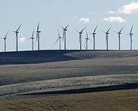
Bristol, UK (SPX) Feb 08, 2011 The new Feed In Tariff in Britain has produced an increased level of interest in small wind farms. Good wind speed estimates are vital for the proper selection of sites but small projects cannot always afford to erect masts. To satisfy this new need, GL Garrad Hassan has developed a wind resource map of Great Britain as part of its global resource mapping range, which includes wind maps for India, Turkey, Lebanon and France. Although there is much publicity and activity attached to offshore wind farms in the UK there is also renewed onshore activity on which this service is focussed. The maps use Mesoscale Compressible Community (MC2) modelling results applied to a microscale flow model in order to predict wind speeds at hub heights of 50 m and 80 m, at 100 m resolution, and are used by individual developers and larger industrial clients. This approach enables thorough consideration of the effect of terrain features on the wind regime at each location within the wind map. GL Garrad Hassan has been making wind speed resource evaluations in the UK for 25 years and these new results have been appraised by GL Garrad Hassan's experts who analyse thousands of megawatts annually. The Mesoscale model was run at 5km resolution with a fixed number of climate states, defined by a global database of geostrophic weather statistics based on reanalysis hindcast data. The results have been used to initiate a linear micro-scale (local) wind flow model. This microscale flow model has been run across the entire land mass of Scotland, England and Wales. Maps at a resolution of 100 m are available electronically in various formats for specific sites, regions or Great Britain in its entirety and wind roses are available to indicate wind direction across the map. Results at the same resolution for Northern Ireland and the Republic of Ireland will be available soon. Wind roses - the visual representation of the wind direction frequency distribution - are constructed from the output of the Mesoscale model. They are available at every point on a 5x5 km grid, providing an indication of wind direction across the map. Based on the predicted wind regime, GL Garrad Hassan's experts also provide energy yield estimates. A map of power density is calculated using the wind speed map and a specific turbine power curve. The estimates take account of GL Garrad Hassan's standard assumptions on losses such as availability, electrical efficiency, turbine performance and environment. These assumptions are based on 25,000MW of wind energy analysis annually, with substantial ongoing validation against operating projects. This approach provides the best possible indicative energy output prediction.
Share This Article With Planet Earth
Related Links GL Garrad Hassan Wind Energy News at Wind Daily
 Construction Begins On Dempsey Ridge Wind Project
Minneapolis MN (SPX) Jan 31, 2011 Mortenson Construction and ACCIONA Energy North America are partnering again to expand wind power in western Oklahoma. The 132-megawatt Dempsey Ridge Wind Farm located on the rolling hills of Roger Mills County is now under construction just 20 miles west of the Red Hills Wind Farm near Elk City, which Mortenson and ACCIONA built together in 2008. During construction of the Dempsey Ridge W ... read more |
|
| The content herein, unless otherwise known to be public domain, are Copyright 1995-2010 - SpaceDaily. AFP and UPI Wire Stories are copyright Agence France-Presse and United Press International. ESA Portal Reports are copyright European Space Agency. All NASA sourced material is public domain. Additional copyrights may apply in whole or part to other bona fide parties. Advertising does not imply endorsement,agreement or approval of any opinions, statements or information provided by SpaceDaily on any Web page published or hosted by SpaceDaily. Privacy Statement |

 del.icio.us
 Digg
Digg Reddit
 YahooMyWeb
 Google